Posts: 2,004
Threads: 7
Joined: Sep 2014
Reputation:
125
The fact of the matter is that most people do not cross at the intersection. Pointing out that there is a crossing 100m down the road doesn't change the status quo, and so people will continue to cross mid-block. A mid-block island is something we have used in several other locations in the region (Laurel Trail and Weber, Margaret near Fairfield, River and the Kolb Creek Trail, several points on Davenport) that experience far less traffic than the Ironhorse Trail. I have a hard time seeing how spending a bit of money to improve the trail's safety isn't justified in this context.
Posts: 2,004
Threads: 7
Joined: Sep 2014
Reputation:
125
(01-24-2018, 01:10 PM)Section ThirtyOne Wrote: My point is, the safe option already exists despite being inconvenient. You want to cross mid-block and save time? Then assume the risks.
People who overdose on fentanyl assume the risk and suffer the consequences, and yet we have a public health crisis and are spending lots of resources to address the epidemic. Rightly, I might add. Just because people don't use the designated crossing point, which others have noted isn't even necessarily the safer or safest option, doesn't absolve the city and region of the issue. They could either build a fence and force people to cross at West/Strange and likely piss off most users of the trail in the best case and discourage them from choosing to walk or cycle in the worst case, or they could respond to the desire-line and make it safer and more useable. The best response seems pretty obvious to me.
Posts: 23
Threads: 0
Joined: Sep 2014
Reputation:
0
01-24-2018, 03:18 PM
(This post was last modified: 01-24-2018, 10:03 PM by kaiserdiver.)
(01-24-2018, 01:10 PM)Section ThirtyOne Wrote: [quote pid='47766' dateline='1516809616']
Why is it not reasonable? Because it is an inconvenience? And living less than 100m from the trail and being a frequent user, I have a good grasp of the concerns thank you very much. My point is, the safe option already exists despite being inconvenient. You want to cross mid-block and save time? Then assume the risks.
[/quote]
A trail is a convenience, isn't it? If it wasn't there, we'd all be using the less convenient (and safe) street system. Jamincan has succinctly explained in the posts above why this particular initiative is reasonable in the context of the trail's use and what has been done in other regional projects.
I'm curious how you approach this crossing, particularly when approaching Victoria Street headed southbound on the IHT. I typically opt to bike down the sidewalk and cross with the cross walk rather than trying to sneak a left turn onto the road across two busy lanes. Do you walk your bike from the trail to the intersection?
Posts: 1,101
Threads: 6
Joined: Aug 2014
Reputation:
99
(01-24-2018, 01:24 PM)jamincan Wrote: People who overdose on fentanyl assume the risk and suffer the consequences, and yet we have a public health crisis and are spending lots of resources to address the epidemic.
Actually, many first responders and others (Border Officers at postal facilities) suffer consequences of fentanyl (and carfentanyl) and shouldn't have to assume any risk. That's a good reason for pumping in resources into it.
Coke
Posts: 811
Threads: 5
Joined: Nov 2015
Reputation:
39
01-24-2018, 05:00 PM
(This post was last modified: 01-24-2018, 05:06 PM by Bob_McBob.)
With respect to Toronto's jaywalking bylaw, this would be a completely acceptable mid-block crossing under the Toronto Police Service's interpretation.
https://www.toronto.ca/311/knowledgebase...gnals.html
I think people who only drive totally lose any sense of appreciation for how onerous these detours can become. A 125m detour for a pedestrian is the same as a 1.5km detour for a car in this area. Would it be acceptable if all traffic on Victoria had to permanently detour to Dominion St and back to cross the intersection (or Glasgow if you include extra delays)? And of course Canard's video clearly demonstrates how ludicrous the situation is for cyclists.
Posts: 2,015
Threads: 11
Joined: Oct 2014
Reputation:
77
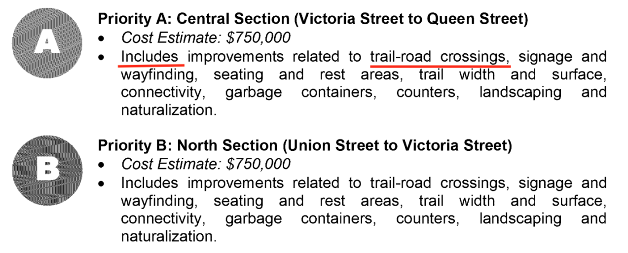
The $2 million price tag referenced is very disingenuous at best; this entire trail section, not the intersection, has a budgeted cost of $750,000:

The total price covers 5.5km of trail improvements, including crossings, and improved amenities.
Personally I've always felt the safer and faster way was always to merge into traffic and turn left like Canard did in his video. Sure there were times people taking the more direct route got across fast, but on average waiting to turn left put got me across ahead or the same as the short-cut.
I was actually hoping to see an island on West too; I actually find that crossing scarier than crossing Victoria at rush hour. The wide lanes on West encourage speeding and vehicles whip around that corner incredibly dangerously; I'm actually surprised that hasn't been more serious crashes there. Especially since the SB vehicles like to cheat the corner and are well in to the NB lane and NB motorists are often swinging wide to go around cyclists or in preparation to get in to the left turn lane.
Interestingly, the City's own video tour of the trail uses the desired path (and also illustrates why 3.6m is not wide enough for the current number users nevermind the future number of users):
Everyone move to the back of the bus and we all get home faster.
Posts: 6,905
Threads: 32
Joined: Oct 2014
Reputation:
224
Posts: 1,520
Threads: 6
Joined: Sep 2014
Reputation:
48
A quick question: which came first, Victoria Street or the railway? When the City (I assume) took over the railway right of way for the IHT, did they retain the full piece (ie including from behind Victoria Bowl, across Victoria, between Kitchener Wilmot Hydro/exLai Lai, across West Ave, and then on towards the park?). Just to be a wag, and if the right-of-way still exists, does that mean the City/trail users have an edge over the Region/road users?
Posts: 434
Threads: 2
Joined: Jun 2015
Reputation:
57
(01-26-2018, 01:29 PM)nms Wrote: A quick question: which came first, Victoria Street or the railway?
Assuming you mean the Preston & Berlin (IHT), the railway predates the current route of Victoria St. See e.g. here.
Quote:When the City (I assume) took over the railway right of way for the IHT, did they retain the full piece (ie including from behind Victoria Bowl, across Victoria, between Kitchener Wilmot Hydro/exLai Lai, across West Ave, and then on towards the park?). Just to be a wag, and if the right-of-way still exists, does that mean the City/trail users have an edge over the Region/road users?
https://youtu.be/4FFG1NqKzCg
Posts: 608
Threads: 0
Joined: Nov 2016
Reputation:
79
(02-01-2018, 12:26 PM)kps Wrote: Assuming you mean the Preston & Berlin (IHT), the railway predates the current route of Victoria St. See e.g. here.
Wow, Ontario St used to be called Foundry, and the train track down Charles went all the way to it. I had vague childhood memories of seeing old track on Charles by the Tannery building, but never could figure out how it would have connected to the track that used to run through Victoria park. I see now that it didn't! Thanks!
...K
Posts: 7,757
Threads: 36
Joined: Jun 2016
Reputation:
211
(02-01-2018, 12:26 PM)kps Wrote: (01-26-2018, 01:29 PM)nms Wrote: A quick question: which came first, Victoria Street or the railway?
Assuming you mean the Preston & Berlin (IHT), the railway predates the current route of Victoria St. See e.g. here.
That's a really interesting map. Neat to see how our city has changed. Also, interesting to see Victoria park *without* a road through it.
Posts: 434
Threads: 2
Joined: Jun 2015
Reputation:
57
(02-01-2018, 01:48 PM)KevinT Wrote: Wow, Ontario St used to be called Foundry, and the train track down Charles went all the way to it.
There's a 1919 aerial photo series with a few views of the area, including this and this. You could be forgiven for not realizing Charles Street is a street.
Quote: I had vague childhood memories of seeing old track on Charles by the Tannery building, but never could figure out how it would have connected to the track that used to run through Victoria park. I see now that it didn't! Thanks!
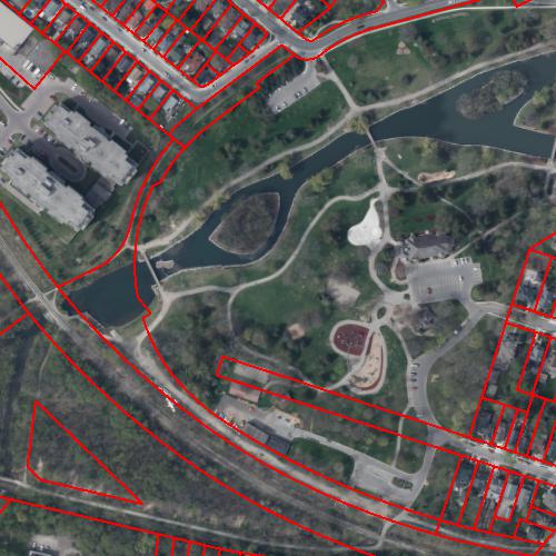
Both railways ran along the edge of Victoria Park, and crossed there — CN (Grand Trunk) which is the remaining one, and CP (Preston & Berlin / Grand River Railway / IHT) which had the tighter curve over to their freight yard on Linden (where the newish townhouses are) and (briefly) ran on Wilmot/Victoria itself to serve Kaufman Rubber. If you look at property boundaries in the city or region GIS, the western edges of Victoria Park are ‘inexplicably’ made of separate narrow curved parcels.

Posts: 608
Threads: 0
Joined: Nov 2016
Reputation:
79
02-01-2018, 05:01 PM
(This post was last modified: 02-01-2018, 05:02 PM by KevinT.)
(02-01-2018, 03:41 PM)kps Wrote: Both railways ran along the edge of Victoria Park, and crossed there — CN (Grand Trunk) which is the remaining one, and CP (Preston & Berlin / Grand River Railway / IHT) which had the tighter curve over to their freight yard on Linden (where the newish townhouses are) and (briefly) ran on Wilmot/Victoria itself to serve Kaufman Rubber.
It was the connection from the Linden yard to Charles that I could never wrap my head around. Turns out there wasn't one, the Charles track switched off the Grand Trunk east of Park:
![[Image: Charles.jpg]](http://www.kevint.ca/wrc/Charles.jpg)
...K
Posts: 434
Threads: 2
Joined: Jun 2015
Reputation:
57
(02-01-2018, 05:01 PM)KevinT Wrote: It was the connection from the Linden yard to Charles that I could never wrap my head around. Turns out there wasn't one, the Charles track switched off the Grand Trunk east of Park:
![[Image: Charles.jpg]](http://www.kevint.ca/wrc/Charles.jpg)
Ah yes. But amazingly CP apparently had a corner from Joseph onto Victoria (Wilmot), which would have been at least as tight. Sadly I've never found a photo showing it.
Posts: 2,015
Threads: 11
Joined: Oct 2014
Reputation:
77
Everyone move to the back of the bus and we all get home faster.
|


![[Image: Charles.jpg]](http://www.kevint.ca/wrc/Charles.jpg)

