Posts: 11
Threads: 0
Joined: Aug 2016
Reputation:
2
(10-04-2016, 11:58 AM)isUsername Wrote: The obstruction sign is also wrong. I don't know whether it should be a gold-and-black chevron type, or a diagonal-down and left type, but it definitely shouldn't be a diagonal-down and right type.
![[Image: obstructions.png]](http://www.smartdrivetest.com/images/SIGNS/road_signs/caution/obstructions.png)
It should be down and left. Unless they really do want buses up on the tracks 
Which if that is the case I'm all for it lol
Posts: 4,466
Threads: 16
Joined: Aug 2014
Reputation:
132
(10-04-2016, 11:49 AM)Canard Wrote: There is a depression in the concrete. Like the platforms for the stations, it's at the crosswalk at the end, where it should be. To have it anywhere else would intice people to cross at an unsafe location.
Well, that's fine then.
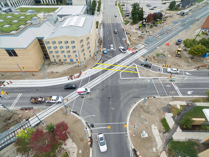
Great overhead shot of Erb and Caroline by the Ion team:
![[Image: 14590154_10154600231822959_1281600324290562472_o.jpg]](https://scontent-lga3-1.xx.fbcdn.net/t31.0-8/14590154_10154600231822959_1281600324290562472_o.jpg)
Posts: 2,163
Threads: 17
Joined: Sep 2014
Reputation:
77
Erb/Caroline. They have created as many problems as they fixed.
Posts: 6,905
Threads: 32
Joined: Oct 2014
Reputation:
224
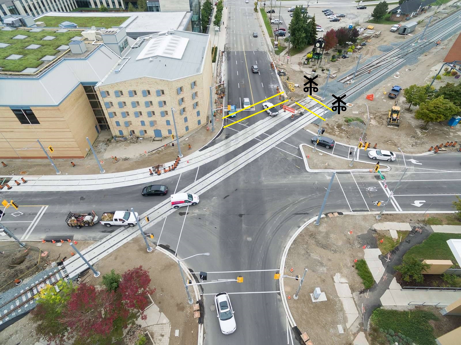
If you mean the upper right crossing in the above image, it can't go straight across because then you need yet another set of railway crossing arms.
Posts: 419
Threads: 1
Joined: Jun 2015
Reputation:
32
(10-04-2016, 01:57 PM)Markster Wrote: Erb/Caroline. They have created as many problems as they fixed.
Let's see what we can come up with:
It looks like the new design helped by:
Streamlining the Westbound traffic flow from Caroline
Making crossing Erb St safer on the E crossing, by a significant decrease in length
Making a preliminary commitment to improve bicycle crossings (that bike box is hopefully a sign of what's to come)
Making crossing Caroline safer on the N crossing, by placing an island (two shorter segments instead of one longer)
Improving train/vehicle safety Northbound by removing that dumb "one shortish car only" box between the rail crossing and the stop line (replacing it by setting the stop lines _way_ back)
It looks like the new design didn't help by:
Complicating the pedestrian Erb St crossing on the W crossing. (Canard comments it might be best of a bad situation due to MTO regs, etc)
Setting the Northbound traffic so far back from the intersection. It is _inviting_ drivers and cyclists to cheat across the tracks.
Planting a light standard in the middle of the sidewalk on the SW corner. Mobility is restricted, reinforcing feelings of hostility to non-motor traffic.
There is no clear picture as of yet how cycling traffic down the new Laurel Trail alignment will be accommodated. If memory serves, the drawings have it emptying straight onto the pedestrian crossing from the NW corner to the pedestrian island with no connection to the concrete MUT alongside the tracks which I presume is the desired connection for cyclists who wish to continue South or East. (As before, West is in-lane cycling nightmare on Erb, and there is no North).
Cyclists in the bike box continuing Southbound will likely try to enter the trackside MUT with too-shallow turns over the tracks, causing accidents unless designed appropriately (maybe paint a perpendicular path?). But maybe since this happens outside of the intersection it doesn't count?
Also, wow but the construction dirt trails make it obvious how _little_ of the intersection is actually used.
What'd I miss (pro or con)?
Posts: 1,195
Threads: 0
Joined: Mar 2015
Reputation:
34
(10-04-2016, 12:37 PM)KevinL Wrote: Great overhead shot of Erb and Caroline by the Ion team:
It's nice to see that they caught that Canada Post van in the middle of making an illegal left turn. 
Posts: 1,709
Threads: 2
Joined: Aug 2014
Reputation:
35
I recognize that there is currently construction blocking the right hand westbound lane of Erb, but looking at the curb, it looks like they're guiding cars making that turn to wind up illegally and dangerously in the left hand lane of Erb.
Posts: 2,163
Threads: 17
Joined: Sep 2014
Reputation:
77
(10-04-2016, 02:29 PM)Canard Wrote: If you mean the upper right crossing in the above image, it can't go straight across because then you need yet another set of railway crossing arms.
I don't have an issue with the island, but the crossing from the island southbound (to the left) is ridiculous. I can't see how crossing arms would be a limiting factor here. What crossing arms are they reusing with this alignment?
chutten, you seem to have gotten every point, good and bad, that I could think of. And then some!
[edit] wait I thought of some more:
* Southbound Caroline's stop bars are set much too far back. That's a legal left-turn-on-red there, and by setting it so far back, it makes it awkward to approach through the bikebox, crosswalk, and then through the excessive extra space to get to a point where you can see approaching traffic.
* In general, turning radiuses all around are too large.
Posts: 6,905
Threads: 32
Joined: Oct 2014
Reputation:
224
I'm just saying if it went straight across they would have to add another railway crossing to get to the other side. Or a fence and block it off.
Posts: 2,163
Threads: 17
Joined: Sep 2014
Reputation:
77
(10-04-2016, 03:40 PM)Canard Wrote: I'm just saying if it went straight across they would have to add another railway crossing to get to the other side. Or a fence and block it off.
But there doesn't appear to be a "railway crossing" at the jaunty crosswalk's south end anyway.
The entire intersection appears to be controlled with regular traffic signals, and no arms.
Posts: 6,905
Threads: 32
Joined: Oct 2014
Reputation:
224
Here's what I mean. Yellow are the "new" crossings that everyone seems to want. If you do this, though, then Transport Canada says "Oops, you're crossing a mainline railway, now you need crossing lights/arms/bells/the works.
The way it's set up now, you can get a "free" crossing by doing it in the road, through the intersection.

Posts: 6,905
Threads: 32
Joined: Oct 2014
Reputation:
224
AND! By the way, the current setup is TWO TIMES BETTER than the alternative everyone seems to want if you're at CIGI and want to go to Knox! Current setup you cross two things. Proposed setup you actually cross *four* things.
Posts: 2,163
Threads: 17
Joined: Sep 2014
Reputation:
77
Yeah, that's not my issue at all! I was wondering what the confusion was.
Also.... I sure hope that they build that rightmost crossing you have painted in there! A "sidewalk" as commonly called.
No, I'm talking about this:

Straighten out that thing to match what any normal person is going to actually walk.
Also... while we're at it, let's give some asphalt that is never going to be used by cars back to pedestrians.
Posts: 1,195
Threads: 0
Joined: Mar 2015
Reputation:
34
I had thought about suggesting returning that asphalt, except it will be used by buses.
The way the crossing is now, it is perpendicular to the tracks, which seems like a good thing for bicycles. Is that the motivation for the crossing being how it is?
Posts: 47
Threads: 0
Joined: Nov 2014
Reputation:
-1
10-04-2016, 04:28 PM
(This post was last modified: 10-04-2016, 04:30 PM by DKsan.)
Well, considering bicycles *shouldn't* use the sidewalk/crosswalks....
Anyways Canard, the rightmost/NW sidewalk crossing will be built, because they have to do the same thing on the southeast side.
And timc is right about why we can't extend out the island.
EDITED.
|


![[Image: obstructions.png]](http://www.smartdrivetest.com/images/SIGNS/road_signs/caution/obstructions.png)
![[Image: 14590154_10154600231822959_1281600324290562472_o.jpg]](https://scontent-lga3-1.xx.fbcdn.net/t31.0-8/14590154_10154600231822959_1281600324290562472_o.jpg)
