Posts: 7,757
Threads: 36
Joined: Jun 2016
Reputation:
212
(09-13-2016, 01:15 PM)ijmorlan Wrote: Are you telling me that drivers didn’t actually have to stop at the crosswalks in Toronto in 1980 which consisted of signs saying it was a crosswalk and more signs encouraging pedestrians to point in order to signal to cars that they want to cross? This is the bit I find the strangest about these level 2 crossovers. The first I heard of them was when I suggested at the Spur Line Trail consultation that Allen St., Union St., and probably some other streets should have pedestrian refuges at the trail. The staff suggested instead one of these “new” crossings but were extremely vague as to how they were different from previous crosswalks. Eventually I found the technical definition somewhere, and remained unimpressed with what they were saying. While I now think I have some understanding of the difference between the two crosswalk styles, they are really relatively minor differences and certainly nothing really new compared to what has existed for decades — it’s really just two slightly different signage and signalling standards.
Also, I was left with the impression that the staff would say almost anything to avoid engaging with my idea. Why not more pedestrian refuges, anyway? Most roads don’t need anything more than a pedestrian refuge, especially if the road is only one lane in each direction. They didn’t answer that question, just talked about a minor variation on the existing concept of a crosswalk as if it were a substantial new idea.
Thanks in any case for the discussion.
The crosswalk situation confused me for a long time as well, because I was taught, and it is true virtually everywhere else (probably in the world but at least in) the US and Canada, that drivers must yield to peds at crosswalks. That apparently isn't true in Ontario.
That's why the Ontario government created the PXO, which is a specific set of lights and signs which mandates pedestrian priority over drivers.
The L2 PXOs are basically just an update to the legally mandated signage which provides the option of leaving out some parts, like expensive lighting and gantries.
L2 PXOs are new though, during the spur line consultation they didn't actually exist yet in Law, so staff would have been hesitant to support them.
Generally though, you're right, regional staff's first priority is to maintain efficient automobile flow and additional pedestrian crossings hampers this. However, the region is currently doing its regular evaluation of the 20 year transportation plan, so, definitely give feedback here: http://www.regionofwaterloo.ca/en/region..._democracy Indicating the need to consider more than just vehicular travel when planning for transportation needs.
Posts: 2,411
Threads: 7
Joined: Aug 2014
Reputation:
51
(09-13-2016, 01:15 PM)ijmorlan Wrote: Why not more pedestrian refuges, anyway? Most roads don’t need anything more than a pedestrian refuge, especially if the road is only one lane in each direction. They didn’t answer that question, just talked about a minor variation on the existing concept of a crosswalk as if it were a substantial new idea.
I agree with this, especially when thinking about a crossing such as Union and the Spur Line. If one of these newfangled level two crossings is put there, what proportion of motorists will be aware of their obligation to stop?
There are plenty of parts of the HTA that motorists routinely ignore, and the vast majority likely have no awareness of. For example, at a cross street, someone on foot has the right of way whether there are any markings or not, or any signals for traffic or not- the crosswalk exists between the two sidewalks.
But how many people would stake their life on a motorist's knowledge of that? And how many will cross at these level two crossings with full confidence that the motorist with enough distance to stop will see the signs, and come to a stop?
Actually, in the case of Union and the Spur Line, a level two crossing isn't even possible given the distance from Moore. But they're no good anywhere since they don't accommodate cyclists. I think your question- "why not more pedestrian refuges, anyway?"- is dead on. On many streets, they'll actually provide safety without depending on motorists to follow the rules, which is the ideal.
Posts: 252
Threads: 1
Joined: Sep 2014
Reputation:
9
I have to cross Union between King & Moore daily either on foot or bike and really wish we had pedestrian refuges anywhere along Union. The only opportunity anyone has to cross Union is to wait for traffic to get backed up for 2-3 blocks due to the lights at King, then walk between the cars which don't leave any space at the intersections. Are you saying it's the law that a driver should stop for a pedestrian walking across, for example, Mary St from one side of Union to the other? I've certainly never experienced that.
Posts: 88
Threads: 0
Joined: Jan 2015
Reputation:
3
Regarding Union, I think the city is planning on re-configuring the street layout some time in the future. It's part of the transportation master plan to be a bike corridor. So some pedestrian enhancements at the crossing may be part of it.
Also, the traffic is especially bad at the moment because it's the only reasonable way to cross King for a couple of km's in both directions. I'm hoping the traffic will go down a lot once erb is re-opened fully. Although I haven't lived in the area when there hasn't been construction.
Posts: 4,414
Threads: 1
Joined: May 2015
Reputation:
191
(09-13-2016, 01:29 PM)MidTowner Wrote: (09-13-2016, 01:15 PM)ijmorlan Wrote: Why not more pedestrian refuges, anyway? Most roads don’t need anything more than a pedestrian refuge, especially if the road is only one lane in each direction. They didn’t answer that question, just talked about a minor variation on the existing concept of a crosswalk as if it were a substantial new idea.
I agree with this, especially when thinking about a crossing such as Union and the Spur Line. If one of these newfangled level two crossings is put there, what proportion of motorists will be aware of their obligation to stop?
[....]
Actually, in the case of Union and the Spur Line, a level two crossing isn't even possible given the distance from Moore. But they're no good anywhere since they don't accommodate cyclists. I think your question- "why not more pedestrian refuges, anyway?"- is dead on. On many streets, they'll actually provide safety without depending on motorists to follow the rules, which is the ideal.
Not only that, but pedestrian refuges work with many motorists’s existing desire to stop for pedestrians. I remember crossing King at the tracks before it closed — four lanes of traffic. Many drivers would stop for me, but it wasn’t as helpful as they believed because I had to worry about both the other direction and the other lane in the same direction. Sometimes I actually found it annoying — I would have rather they just drove on and been out of the way. With a pedestrian refuge, this is reduced down to just worrying about one direction, which in turn means one peleton of cars coming from a green light (instead of two, one from each direction). When the road is only one lane in each direction, this is further reduced to being confident that if a car has stopped for me, I can safely cross in front of it. So it takes advantage of an existing instinct towards helpfulness, rather than emphasizing command-and-control which like it or not is what traffic signals are.
In short, pedestrian refuges are way underused. Even very busy roads can be quite safe to cross with a refuge since the traffic often comes in waves controlled by signals.
Posts: 262
Threads: 3
Joined: Aug 2014
Reputation:
22
(09-13-2016, 01:14 PM)danbrotherston Wrote: First of all, multi-use trails do not have to intersect with streets at crosswalks....they may simply intersect streets with no provisions whatsoever, as they do for most Iron Horse Trail intersections.
If they're alongside a street and cross another street, they're generally treated as crosswalks. Whether they have to or not? That's a good question.
(09-13-2016, 01:15 PM)ijmorlan Wrote: What I mean is, make the trail be a street. Which it should be anyway for other reasons — all our trails are marked as parks, with signs saying they are closed overnight. What kind of transportation corridor is closed overnight?
A street with bicycle lanes in both directions and no general traffic lanes. I’ll admit this idea is bogus as a way of dealing with the existing rules if you can find a regulation which states that a street must have a general traffic lane.
OK, interesting idea. I hadn't pulled out that distinction.
Quote:Are you telling me that drivers didn’t actually have to stop at the crosswalks in Toronto in 1980 which consisted of signs saying it was a crosswalk and more signs encouraging pedestrians to point in order to signal to cars that they want to cross? This is the bit I find the strangest about these level 2 crossovers. The first I heard of them was when I suggested at the Spur Line Trail consultation that Allen St., Union St., and probably some other streets should have pedestrian refuges at the trail. The staff suggested instead one of these “new” crossings but were extremely vague as to how they were different from previous crosswalks. Eventually I found the technical definition somewhere, and remained unimpressed with what they were saying. While I now think I have some understanding of the difference between the two crosswalk styles, they are really relatively minor differences and certainly nothing really new compared to what has existed for decades — it’s really just two slightly different signage and signalling standards.
I shouldn't have said with such certainty that they're a first. But, I'm not sure what the rules were in Toronto in 1980, whether there was municipal bylaw in effect, whether anything was deliberately changed since then. What we have crosswalks away from intersections now, though, there isn't an obligation for cars to stop unless there's an activated signal.
Quote:Also, I was left with the impression that the staff would say almost anything to avoid engaging with my idea. Why not more pedestrian refuges, anyway? Most roads don’t need anything more than a pedestrian refuge, especially if the road is only one lane in each direction. They didn’t answer that question, just talked about a minor variation on the existing concept of a crosswalk as if it were a substantial new idea.
Yes, I've also seen staff avoiding engaging, and huge reluctance to new or different ideas. Often they need to hear about it from multiple different directions.
More pedestrian refuges are something that I've seen a lot of buy-in lately from local staff and politicians. And they're hard not to like-- the region itself quotes "as much as 80%" reduction in collisions as a result. We're seeing more and more and I expect that to continue. There's locations on Spur Line trail that would benefit from an island (like Union!)
Posts: 495
Threads: 1
Joined: Jan 2015
Reputation:
20
09-13-2016, 04:20 PM
(This post was last modified: 09-13-2016, 04:20 PM by Elmira Guy.)
There are two new pedestrian refuges on Lincoln St in Waterloo. At least I believe that's what they are.
Posts: 7,757
Threads: 36
Joined: Jun 2016
Reputation:
212
(09-13-2016, 04:00 PM)zanate Wrote: (09-13-2016, 01:14 PM)danbrotherston Wrote: First of all, multi-use trails do not have to intersect with streets at crosswalks....they may simply intersect streets with no provisions whatsoever, as they do for most Iron Horse Trail intersections.
If they're alongside a street and cross another street, they're generally treated as crosswalks. Whether they have to or not? That's a good question.
Yes, boulevard trails generally have crosswalks, and generally drivers are required to yield to peds because it's a controlled intersection. But here, I think, crossrides are permitted, at least those are the designs I saw for crossrides. I think it is only PXOs which don't have provisions for crossrides.
But I was intending to mean midblock crossings as part of non boulevard MUTs.
(09-13-2016, 04:00 PM)zanate Wrote: OK, interesting idea. I hadn't pulled out that distinction.
Yes, this is an interesting idea lol. It's one of these rare legal thought experiments, that might just make sense in practice.
(09-13-2016, 04:00 PM)zanate Wrote: I shouldn't have said with such certainty that they're a first. But, I'm not sure what the rules were in Toronto in 1980, whether there was municipal bylaw in effect, whether anything was deliberately changed since then. What we have crosswalks away from intersections now, though, there isn't an obligation for cars to stop unless there's an activated signal.
My impression is this is when L1 PXOs were introduced. I would guess there is some correlation there.
(09-13-2016, 04:00 PM)zanate Wrote: More pedestrian refuges are something that I've seen a lot of buy-in lately from local staff and politicians. And they're hard not to like-- the region itself quotes "as much as 80%" reduction in collisions as a result. We're seeing more and more and I expect that to continue. There's locations on Spur Line trail that would benefit from an island (like Union!)
Yes, pedestrian refuges are hard not to like, yet somehow the residents of Westheights Dr. managed. Go figure.
Posts: 6,905
Threads: 32
Joined: Oct 2014
Reputation:
224
09-18-2016, 11:00 AM
(This post was last modified: 09-18-2016, 11:02 AM by Canard.)
So I was all excited to ride the "Walter Bean Trail this morning. I parked at Freeport and started riding. Google said "Green" For cycle paths and I had planned on going to Conestoga College and back.
2 km in, I see this sign:
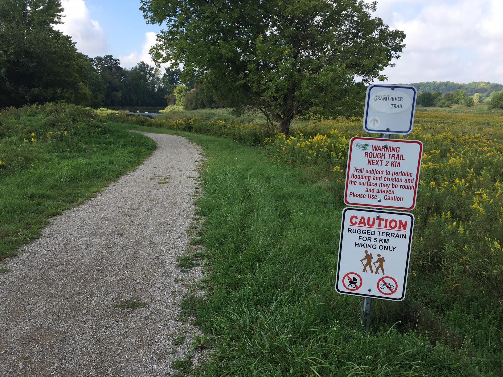
Then the trails turn to this:
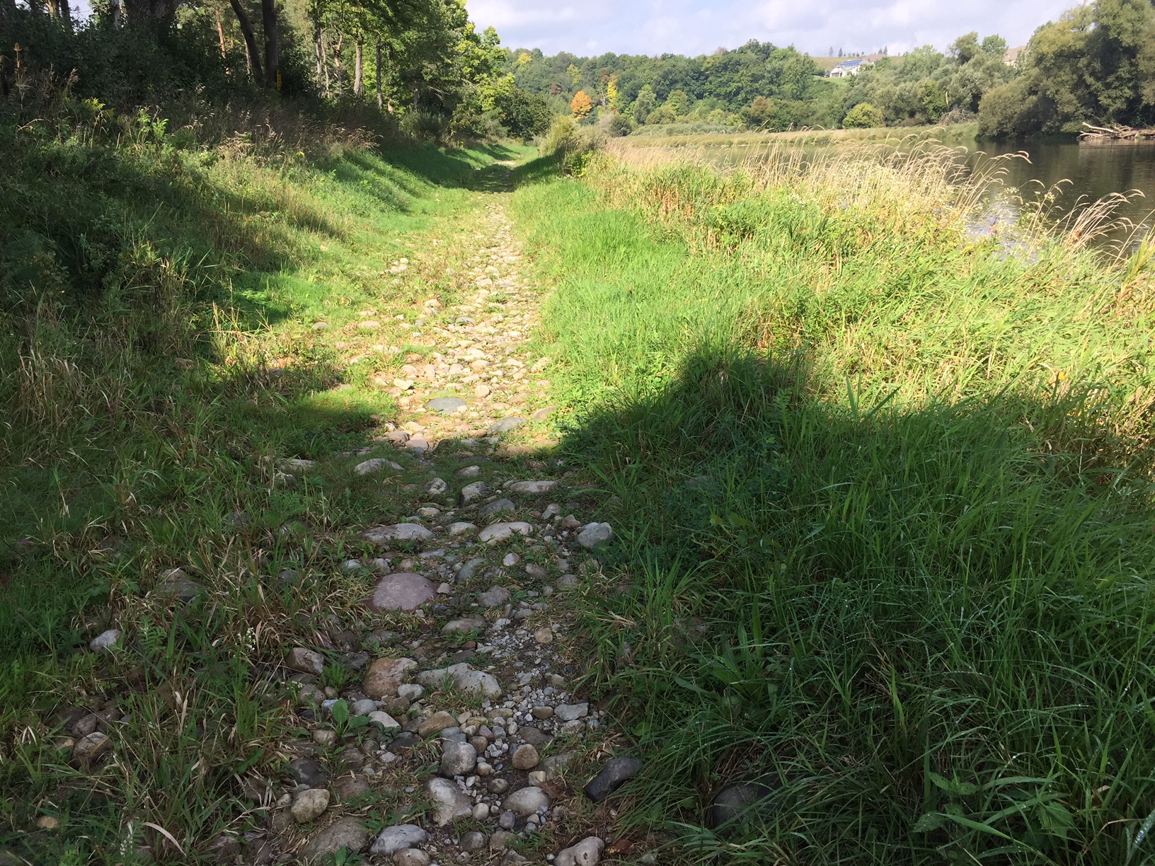
...and eventually, this:
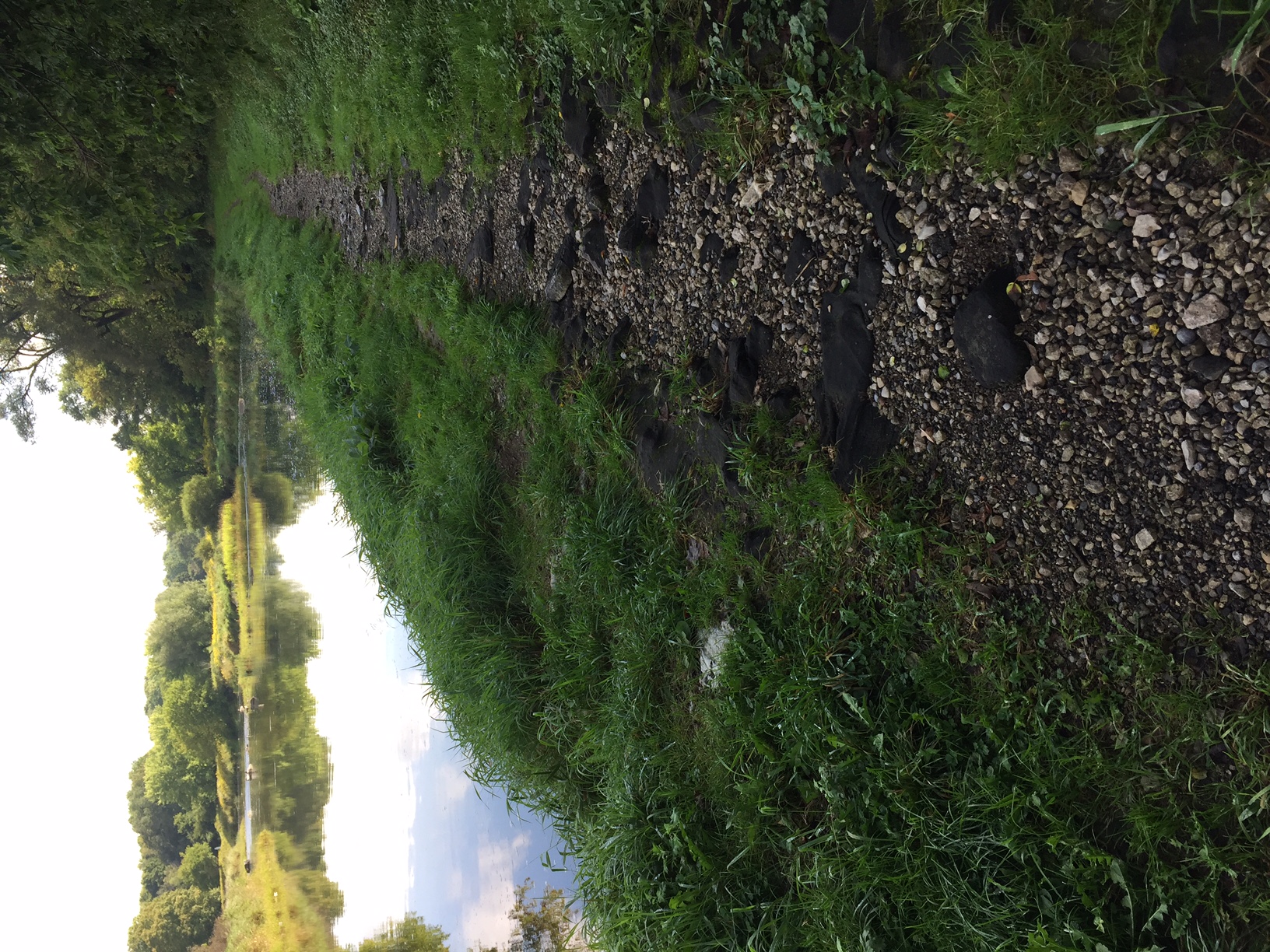
Why does google lie?  This looked like such a fun run. I had to abort.
Will this ever get upgraded?
Posts: 2,163
Threads: 17
Joined: Sep 2014
Reputation:
77
Which section of the trail?
Someone can at least go to https://mapmaker.google.com/mapmaker and set the trail type to "dirt" which will make it brown in colour.
Posts: 6,905
Threads: 32
Joined: Oct 2014
Reputation:
224
09-18-2016, 11:30 AM
(This post was last modified: 09-18-2016, 11:55 AM by Canard.)
Ummmm give me a few. I'll check when I get home. Trying the South end now.
When I see how inaccurate Google is (dirt vs. Paved) I realize I should have been writing down the transition points between surfaces! I'd do it next time but I don't think I'll be returning here again.
Posts: 7,757
Threads: 36
Joined: Jun 2016
Reputation:
212
Google Maps is terribly inaccurate when it comes to trail conditions, the gravel/paved isn't reliable 9 times out of 10. But even if it was, there's no indication of crossing conditions, nor is paved/unpaved sufficient data to know if a trail is usable. I've seen some pretty cruddy paved trails, and generally unpaved could mean anything from 3 meter wide crushed stone hard pack trail all the way to barely single track, washed out half the time etc.
But I don't blame Google. City/region maps are equally terrible. The new region bike map has equally poor information, and I'm pretty sure has trails marked which don't exist in any form.
There is definitely a challenge in mapping, but there's also a challenge in simply setting standard for trails. Of course, it doesn't help when some people don't even agree that paving is a good thing.
Posts: 7,757
Threads: 36
Joined: Jun 2016
Reputation:
212
(09-18-2016, 11:13 AM)Markster Wrote: Which section of the trail?
Someone can at least go to https://mapmaker.google.com/mapmaker and set the trail type to "dirt" which will make it brown in colour.
Technically, the whole Grand River trail should be marked as "unpaved", as none of it is paved. Most of the trails in the city should be marked this way.
Posts: 2,163
Threads: 17
Joined: Sep 2014
Reputation:
77
Here's the options for trail conditions:
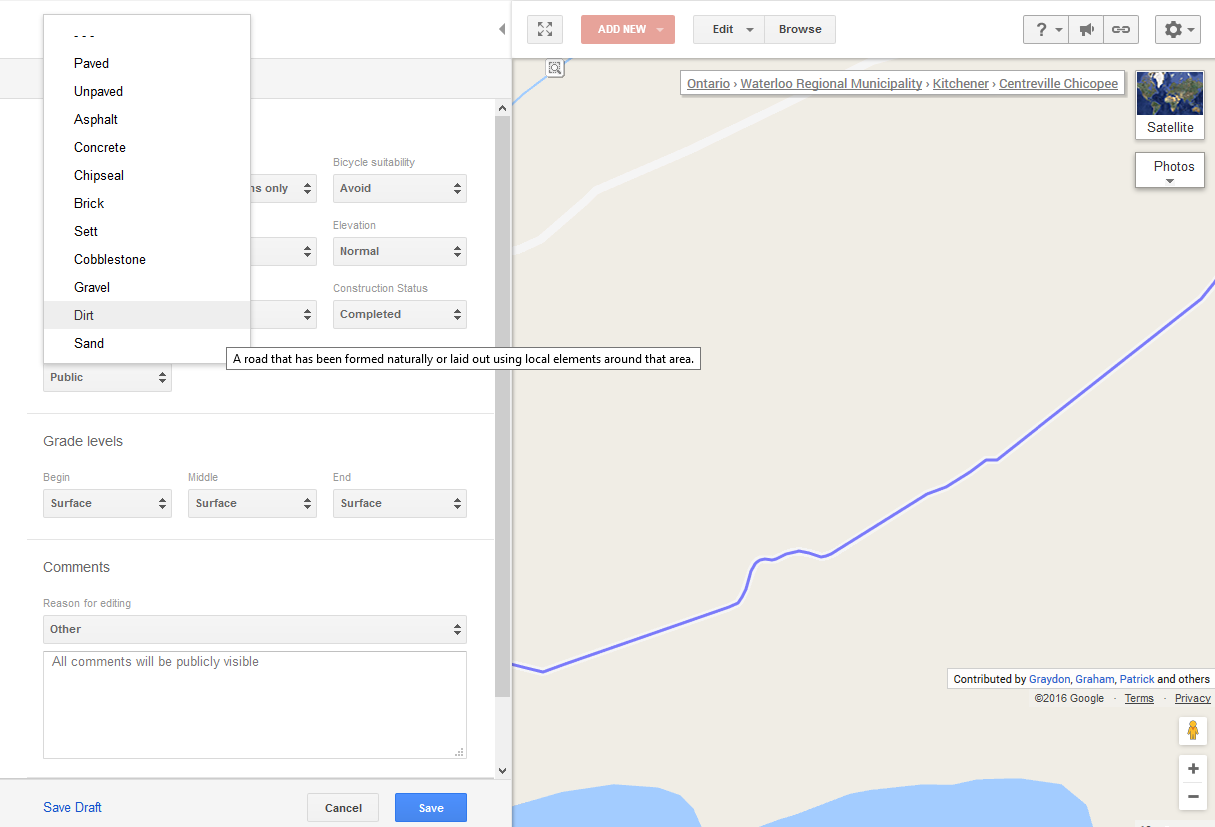
For display purposes, it all just gets displayed as either:
a) Brown
b) Green
If you set something as "pedestrians only" then it removes any highlighting. Particularly rough sections of trail should probably have that setting on. However, it's tough to know exactly where to draw the line between navigable and not.
The data is ultimately only as good as the amount of effort volunteers are willing to put in.
Posts: 6,905
Threads: 32
Joined: Oct 2014
Reputation:
224
It's barely even walkable - you'd roll an ankle so easilly!
Based on your criteria above, the trail should be set to "Dirt" everywhere between Blair Road and Freeport, and "Pedestrian Only" in the gap where I did not ride in the image below:
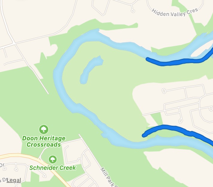
This way, when Google is set to "cycling" it just won't show up, here - as it truly is not cyclable.
|


 This looked like such a fun run. I had to abort.